TriniTuner.com  |  Latest Event:  

Forums

The official tropical weather thread 2018

this is how we do it.......

Moderator: 3ne2nr Mods

User avatar
Duane 3NE 2NR
Admin
Posts: 27252
Joined: March 24th, 2003, 10:27 am
Location: T&T
Contact:

Re: The official tropical weather thread 2018

Postby Duane 3NE 2NR » July 4th, 2018, 11:26 pm

Image

User avatar
shake d livin wake d dead
TunerGod
Posts: 31741
Joined: July 20th, 2009, 1:25 pm
Location: all over

Re: The official tropical weather thread 2018

Postby shake d livin wake d dead » July 5th, 2018, 4:59 am

passing us clean....may very well be the first ts or hurricane
Attachments
two_atl_5d0 (1).png

redmanjp
TriniTuner 24-7
Posts: 16283
Joined: September 22nd, 2009, 11:01 pm
Contact:

Re: The official tropical weather thread 2018

Postby redmanjp » July 5th, 2018, 10:29 am

islands should issue watches just in case (not warnings)

https://www.nhc.noaa.gov/
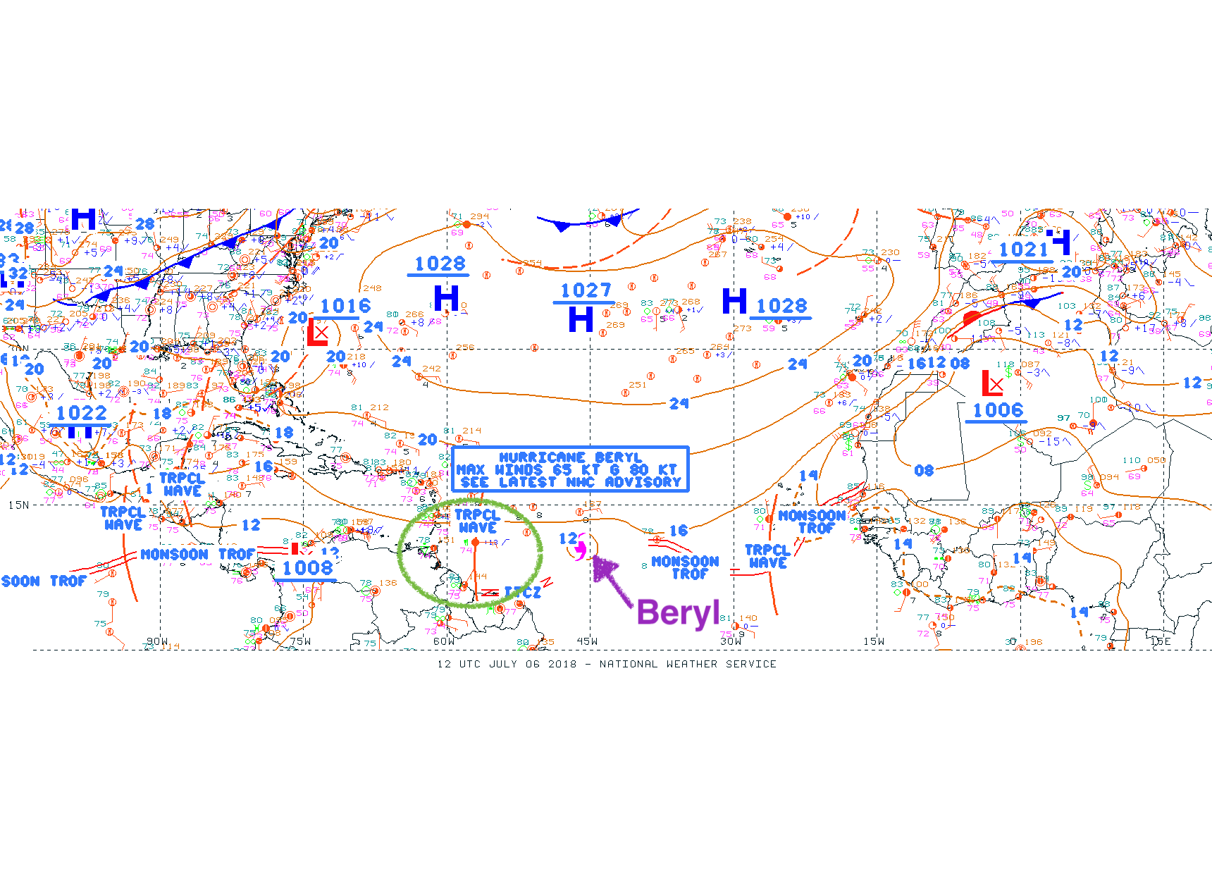
Special Message from NHC Issued 5 Jul 2018 14:11 UTC
NHC will initiate advisories at 11 AM AST/EDT on Tropical Depression Two located over the central tropical Atlantic Ocean.

User avatar
hydroep
3ne2nr Toppa Toppa
Posts: 5018
Joined: February 4th, 2007, 9:16 pm

Re: The official tropical weather thread 2018

Postby hydroep » July 5th, 2018, 11:33 am

000
WTNT32 KNHC 051442
TCPAT2

BULLETIN
Tropical Depression Two Advisory Number 1
NWS National Hurricane Center Miami FL AL022018
1100 AM AST Thu Jul 05 2018

...TROPICAL DEPRESSION FORMS OVER THE CENTRAL TROPICAL ATLANTIC...
...EXPECTED TO DISSIPATE EAST OF THE LESSER ANTILLES OVER THE
WEEKEND...


SUMMARY OF 1100 AM AST...1500 UTC...INFORMATION
-----------------------------------------------
LOCATION...10.2N 41.4W
ABOUT 1385 MI...2230 KM ESE OF THE LESSER ANTILLES
MAXIMUM SUSTAINED WINDS...35 MPH...55 KM/H
PRESENT MOVEMENT...W OR 270 DEGREES AT 16 MPH...26 KM/H
MINIMUM CENTRAL PRESSURE...1009 MB...29.80 INCHES


WATCHES AND WARNINGS
--------------------
There are no coastal watches or warnings in effect.


DISCUSSION AND OUTLOOK
----------------------
At 1100 AM AST (1500 UTC), the center of Tropical Depression Two was
located near latitude 10.2 North, longitude 41.4 West. The
depression is moving toward the west near 16 mph (26 km/h). A fast
westward to west-northwestward motion is expected through the
weekend.

Maximum sustained winds are near 35 mph (55 km/h) with higher gusts.
Some strengthening is possible, and the depression could become a
tropical storm later today or on Friday. The system is forecast to
degenerate into an open trough east of the Lesser Antilles over the
weekend.

The estimated minimum central pressure is 1009 mb (29.80 inches).


HAZARDS AFFECTING LAND
----------------------
None


NEXT ADVISORY
-------------
Next complete advisory at 500 PM AST.

Forecaster Berg


https://www.nhc.noaa.gov/text/refresh/MIATCPAT2+shtml/051442.shtml

User avatar
shake d livin wake d dead
TunerGod
Posts: 31741
Joined: July 20th, 2009, 1:25 pm
Location: all over

Re: The official tropical weather thread 2018

Postby shake d livin wake d dead » July 5th, 2018, 12:04 pm

neighbors up north better start preparing for the worse

User avatar
Duane 3NE 2NR
Admin
Posts: 27252
Joined: March 24th, 2003, 10:27 am
Location: T&T
Contact:

The official tropical weather thread 2018

Postby Duane 3NE 2NR » July 5th, 2018, 12:32 pm

that Sarahan dust
Attachments
4bcc9238-c0ed-49b6-bbdf-735e5d8e0e43.jpg

redmanjp
TriniTuner 24-7
Posts: 16283
Joined: September 22nd, 2009, 11:01 pm
Contact:

Re: The official tropical weather thread 2018

Postby redmanjp » July 5th, 2018, 2:55 pm

https://www.nhc.noaa.gov/text/refresh/MIATCUAT2+shtml/051830.shtml?

Tropical Storm Beryl Tropical Cyclone Update
NWS National Hurricane Center Miami FL AL022018
230 PM AST Thu Jul 05 2018

...DEPRESSION BECOMES TROPICAL STORM BERYL...

Satellite imagery indicates that the tropical depression has
strengthened and is now Tropical Storm Beryl. Maximum sustained
winds are estimated to be 40 mph (65 km/h) with higher gusts. An
updated intensity forecast will be provided with the 500 PM AST
(2100 UTC) advisory.


SUMMARY OF 230 PM AST...1830 UTC...INFORMATION
---------------------------------------------------
LOCATION...10.3N 42.3W
ABOUT 1330 MI...2140 KM ESE OF THE LESSER ANTILLES
MAXIMUM SUSTAINED WINDS...40 MPH...65 KM/H
PRESENT MOVEMENT...W OR 275 DEGREES AT 16 MPH...26 KM/H
MINIMUM CENTRAL PRESSURE...1007 MB...29.74 INCHES


antigua issued an alert

http://antiguamet.com/Antigua_Met_files/ALERT_STATEMENTS/alertStatement_The%20Leeward%20islands%20and%20British%20Virgin%20Islands.html

bluefete
TriniTuner 24-7
Posts: 13312
Joined: November 12th, 2008, 10:56 pm
Location: POS

Re: The official tropical weather thread 2018

Postby bluefete » July 5th, 2018, 4:04 pm

https://www.facebook.com/TTWeatherCenter/

Adverse Weather Watch #1: Showers and Thunderstorms Likely on Saturday as ITCZ modulated by Tropical Storm Beryl to affect Trinidad and Tobago. There is NO tropical storm threat, watch or warning for Trinidad and Tobago!

Start date: Sat, Jul 7, 2018 12:00 AM
End date: Sat, Jul 7, 2018 5:00 PM

Description: Showers, at times heavy, is expected in varying localities and thunderstorms in few areas on Saturday. Gusty winds and street or flash flooding are likely in areas of heavy showers. This event is related to the ITCZ (Inter Tropical Convergence Zone), being modulated by Tropical Depression #2

Instructions: Persons should monitor weather conditions and official updates.

Full information: http://www.metoffice.gov.tt/early_warning

User avatar
De Dragon
TriniTuner 24-7
Posts: 17902
Joined: January 27th, 2004, 3:49 am
Location: Enjoying my little miracles............

Re: The official tropical weather thread 2018

Postby De Dragon » July 5th, 2018, 4:06 pm

Feeling it for the already flooded out people all over T&T.

bluefete
TriniTuner 24-7
Posts: 13312
Joined: November 12th, 2008, 10:56 pm
Location: POS

Re: The official tropical weather thread 2018

Postby bluefete » July 5th, 2018, 4:09 pm

De Dragon wrote:Feeling it for the already flooded out people all over T&T.


Me too.

One good shower of rain last week and people all over the place were bawling.

User avatar
shake d livin wake d dead
TunerGod
Posts: 31741
Joined: July 20th, 2009, 1:25 pm
Location: all over

Re: The official tropical weather thread 2018

Postby shake d livin wake d dead » July 5th, 2018, 7:08 pm

Hopefully no kinda outa timing cat 3,4,5 hurricane business like last year..

User avatar
sMASH
TunerGod
Posts: 22139
Joined: January 11th, 2005, 4:30 am

Re: The official tropical weather thread 2018

Postby sMASH » July 5th, 2018, 8:37 pm

haul yuh.....

we getting ting this year.. to much energy in the oceans...

redmanjp
TriniTuner 24-7
Posts: 16283
Joined: September 22nd, 2009, 11:01 pm
Contact:

Re: The official tropical weather thread 2018

Postby redmanjp » July 5th, 2018, 10:16 pm

sMASH wrote:haul yuh.....

we getting ting this year.. to much energy in the oceans...


There was an article sometime ago in which the Met Office said that storms were tracking more southerly since 2015 which would put us at risk- well Bret came last year and it might very well be a dress rehearsal for what might hit us this year

redmanjp
TriniTuner 24-7
Posts: 16283
Joined: September 22nd, 2009, 11:01 pm
Contact:

Re: The official tropical weather thread 2018

Postby redmanjp » July 5th, 2018, 11:36 pm

Maximum sustained winds have increased to near 65 mph (100 km/h)
with higher gusts. Additional strengthening is forecast, and Beryl
could become a hurricane on Friday
. Beryl is forecast to degenerate
into a strong open trough just east of the Lesser Antilles over the
weekend.


hope they right about that wind shear weakening it before it reach d islands

User avatar
shake d livin wake d dead
TunerGod
Posts: 31741
Joined: July 20th, 2009, 1:25 pm
Location: all over

Re: The official tropical weather thread 2018

Postby shake d livin wake d dead » July 6th, 2018, 5:55 am

thing is a cat 1 yes...seigonne say sat into sun we could be affected lil bit

Sundar
Riding on 17's
Posts: 1443
Joined: July 5th, 2012, 12:33 pm
Location: Rock Road
Contact:

Re: The official tropical weather thread 2018

Postby Sundar » July 6th, 2018, 6:19 am

redmanjp wrote:
sMASH wrote:haul yuh.....

we getting ting this year.. to much energy in the oceans...


There was an article sometime ago in which the Met Office said that storms were tracking more southerly since 2015 which would put us at risk- well Bret came last year and it might very well be a dress rehearsal for what might hit us this year

Way South hit us like a circular saw along the Southern coast. .

User avatar
Dizzy28
TriniTuner 24-7
Posts: 16802
Joined: February 8th, 2010, 8:54 am
Location: People's Republic of Bananas

Re: The official tropical weather thread 2018

Postby Dizzy28 » July 6th, 2018, 9:24 am

CNN calling it Tiny Beryl....
Lets hope it doesn't prove them wrong.

User avatar
Duane 3NE 2NR
Admin
Posts: 27252
Joined: March 24th, 2003, 10:27 am
Location: T&T
Contact:

Re: The official tropical weather thread 2018

Postby Duane 3NE 2NR » July 6th, 2018, 10:16 am

*Specifically for Trinidad and Tobago*: Both islands are NOT under any tropical storm threat, watch or warning.

An Adverse Weather Alert, likely to be raised to an Adverse Weather Watch later today by the Trinidad and Tobago Meteorological Service, is in effect for Saturday 7th July 2018.

Scattered moderate to heavy showers, thunderstorms are likely due the an active Inter-Tropical Convergence Zone modulated by Hurricane Beryl.

Beryl will remain well north of Trinidad and Tobago and due to it’s small circulation, will not directly impact Trinidad and Tobago’s weather via feeder bands nor seas by long period swells. Seas will remain slight to moderate with waves generally up to 1.5 meters in open waters, occasionally up to 2.0 meters and generally up to 1.0 meter in sheltered areas. Weather-wise, rainfall accumulations now through 2:00AM Monday 9th July 2018, are forecast to be generally 15-25 mm across both Trinidad and Tobago, with isolated areas, favoring eastern parts of both islands, receiving up to 40 mm.Gusty winds, street/flash flooding may accompany heavier showers and thunderstorms on Saturday.

Image

redmanjp
TriniTuner 24-7
Posts: 16283
Joined: September 22nd, 2009, 11:01 pm
Contact:

Re: The official tropical weather thread 2018

Postby redmanjp » July 6th, 2018, 12:16 pm

stronger

https://www.nhc.noaa.gov/text/refresh/MIATCPAT2+shtml/061435.shtml?
BULLETIN
Hurricane Beryl Advisory Number 5
NWS National Hurricane Center Miami FL AL022018
1100 AM AST Fri Jul 06 2018

...BRAZEN BERYL A LITTLE STRONGER...
...NOW FORECAST TO STILL BE A HURRICANE AS IT APPROACHES THE LESSER
ANTILLES...


SUMMARY OF 1100 AM AST...1500 UTC...INFORMATION
-----------------------------------------------
LOCATION...10.7N 46.5W
ABOUT 1045 MI...1685 KM ESE OF THE LESSER ANTILLES
MAXIMUM SUSTAINED WINDS...80 MPH...130 KM/H
PRESENT MOVEMENT...W OR 275 DEGREES AT 15 MPH...24 KM/H
MINIMUM CENTRAL PRESSURE...994 MB...29.36 INCHES


WATCHES AND WARNINGS
--------------------
There are no coastal watches or warnings in effect.

Interests in the Lesser Antilles should monitor the progress of
Beryl, as hurricane watches could be needed for some of the islands
by tonight.


DISCUSSION AND OUTLOOK
----------------------
At 1100 AM AST (1500 UTC), the eye of Hurricane Beryl was located
near latitude 10.7 North, longitude 46.5 West. Beryl is moving
toward the west near 15 mph (24 km/h). A faster westward to
west-northwestward motion is expected to begin over the weekend and
continue through early next week. On the forecast track, the
center of Beryl will approach the Lesser Antilles over the weekend
and cross the island chain late Sunday or Monday.

Maximum sustained winds have increased to near 80 mph (130 km/h)
with higher gusts. Additional strengthening is forecast during the
next couple of days, and Beryl is expected to still be a hurricane
when it reaches the Lesser Antilles late Sunday or Monday.
Weakening is expected once Beryl reaches the eastern Caribbean
Sea on Monday, but the system may not degenerate into an open trough
until it reaches the vicinity of Hispaniola and the central
Caribbean Sea.

Beryl is a compact hurricane. Hurricane-force winds extend outward
up to 10 miles (20 km) from the center, and tropical-storm-force
winds extend outward up to 35 miles (55 km).

The estimated minimum central pressure is 994 mb (29.36 inches).


HAZARDS AFFECTING LAND
----------------------
None.


NEXT ADVISORY
-------------
Next complete advisory at 500 PM AST.

redmanjp
TriniTuner 24-7
Posts: 16283
Joined: September 22nd, 2009, 11:01 pm
Contact:

Re: The official tropical weather thread 2018

Postby redmanjp » July 6th, 2018, 12:21 pm

http://metoffice.gov.tt/early_warning
Adverse Weather Warning # 2 - Yellow Level
Adverse Weather - Sat, Jul 7, 2018 12:00 AM to Sat, Jul 7, 2018 2:00 PM
Status - Actual Message
Type - Update
Alert - Adverse Weather
Response - Monitor Conditions
Urgency - Expected
Severity - Moderate Certainty - Likely
Category - Met

Start date (local time) Sat, Jul 7, 2018 12:00 AM
End date (local time) Sat, Jul 7, 2018 2:00 PM
Headline Adverse Weather Warning # 2 - Yellow Level

Description

Showers and isolated thunderstorms, at times heavy are expected Saturday 7th July, 2018 from midnight. Gusty winds and street or flash flooding are likely in areas of heavy downpours. This event is due to the ITCZ (Inter Tropical Convergence Zone). Please note also, that Hurricane Beryl on its current track, poses no direct threat to Trinidad and Tobago. An update to this advisory will be issued as warranted.

Instructions

Monitor weather conditions and updates from official sources. Plan safety measures. Follow the instructions of government officials. More information: http://www.odpm.gov.tt
Area description Trinidad and Tobago

User avatar
Duane 3NE 2NR
Admin
Posts: 27252
Joined: March 24th, 2003, 10:27 am
Location: T&T
Contact:

Re: The official tropical weather thread 2018

Postby Duane 3NE 2NR » July 6th, 2018, 4:11 pm

So MET office is saying we won't be affected by Beryl, but will be affected by the Tropical Wave currently east of us (circled in green) starting early Saturday morning. That tropical wave is what the Adverse Weather Warning # 2 - Yellow Level for Trinidad & Tobago is about.

Image

pugboy
TunerGod
Posts: 25595
Joined: September 6th, 2003, 6:18 pm

Re: The official tropical weather thread 2018

Postby pugboy » July 6th, 2018, 4:17 pm

They don't want to be caught napping like last week lol

User avatar
streetbeastINC.
punchin NOS
Posts: 3602
Joined: April 17th, 2003, 11:48 pm
Contact:

Re: The official tropical weather thread 2018

Postby streetbeastINC. » July 6th, 2018, 5:27 pm

Our met office also said yesterday on 12 noon news that there was no likelihood that the disturbance will manifest into a ts or even had a chance, although before i left home i read NOAA forecasting said it was going to develop.......

User avatar
X_Factor
TriniTuner 24-7
Posts: 9527
Joined: April 27th, 2003, 5:54 pm
Location: St. Augustine
Contact:

Re: The official tropical weather thread 2018

Postby X_Factor » July 6th, 2018, 8:12 pm

better hope and pray beryl starts heading north soon as predicted or else its gonna be a serious 1-2 punch

joker
Shifting into 6th
Posts: 1949
Joined: August 18th, 2006, 3:44 pm
Location: 9sm

Re: The official tropical weather thread 2018

Postby joker » July 6th, 2018, 10:02 pm

I also noticed that discussion..
Monitoring!

User avatar
shake d livin wake d dead
TunerGod
Posts: 31741
Joined: July 20th, 2009, 1:25 pm
Location: all over

Re: The official tropical weather thread 2018

Postby shake d livin wake d dead » July 6th, 2018, 10:19 pm

So expect more floods this weekend?

randolphinshan
Riding on 17's
Posts: 1361
Joined: November 20th, 2013, 12:08 pm

Re: The official tropical weather thread 2018

Postby randolphinshan » July 6th, 2018, 10:54 pm

shake d livin wake d dead wrote:So expect more floods this weekend?

Put those billion dollar box drains built by you know who, to the test..

User avatar
X_Factor
TriniTuner 24-7
Posts: 9527
Joined: April 27th, 2003, 5:54 pm
Location: St. Augustine
Contact:

Re: The official tropical weather thread 2018

Postby X_Factor » July 6th, 2018, 10:59 pm

the northward movement on the tracking seem to have started so we should be in the general clear zone for beryl

User avatar
Duane 3NE 2NR
Admin
Posts: 27252
Joined: March 24th, 2003, 10:27 am
Location: T&T
Contact:

Re: The official tropical weather thread 2018

Postby Duane 3NE 2NR » July 6th, 2018, 11:20 pm

X_Factor wrote:the northward movement on the tracking seem to have started so we should be in the general clear zone for beryl

for sure. I think the ODPM Public Advisory is more for the tropical wave

User avatar
novastar1
3NE2NR is my LIFE
Posts: 888
Joined: November 24th, 2008, 7:02 pm
Location: On tuner... Sometimes

Re: The official tropical weather thread 2018

Postby novastar1 » July 7th, 2018, 1:37 am

X_Factor wrote:the northward movement on the tracking seem to have started so we should be in the general clear zone for beryl
You mean...... God is ah Trini

Advertisement

Return to “Ole talk and more Ole talk”

Who is online

Users browsing this forum: Google [Bot] and 294 guests