TriniTuner.com  |  Latest Event:  

Forums

The official tropical weather thread 2017

this is how we do it.......

Moderator: 3ne2nr Mods

User avatar
V2NR 3.0
punchin NOS
Posts: 3235
Joined: February 6th, 2006, 11:10 am
Location: San Juan

Re: The official tropical weather thread 2016

Postby V2NR 3.0 » June 2nd, 2016, 6:39 am

In San Juan, it was like a mini hurricane. That woke me up shortly after 2 this morning. Love this weather !

User avatar
gastly369
TriniTuner 24-7
Posts: 10062
Joined: May 15th, 2009, 4:40 pm
Location: trinidad

Re: The official tropical weather thread 2016

Postby gastly369 » June 2nd, 2016, 5:47 pm

Well fk... we doh have ah mango tree in we yard and ah find some this morning

link
18 pounds of Boost
Posts: 2346
Joined: September 15th, 2004, 11:03 pm

Re: The official tropical weather thread 2016

Postby link » June 26th, 2016, 9:35 am

bump for a great sunny outlook for circuit racing today :D

User avatar
Duane 3NE 2NR
Admin
Posts: 27225
Joined: March 24th, 2003, 10:27 am
Location: T&T
Contact:

Re: The official tropical weather thread 2016

Postby Duane 3NE 2NR » June 26th, 2016, 11:14 am

Yup sunny Sunday at Wallerfield.
The Atlantic Basin and ITCZ are very quiet at the moment.

User avatar
Kalisnakov
3NE2NR is my LIFE
Posts: 852
Joined: January 21st, 2014, 6:29 pm

Re: The official tropical weather thread 2016

Postby Kalisnakov » July 4th, 2016, 6:20 am

Rel rain in aranjuez

User avatar
b14inb12
Trinituner Peong
Posts: 444
Joined: January 25th, 2008, 5:57 am
Location: trinidad and tobago
Contact:

Re: The official tropical weather thread 2016

Postby b14inb12 » July 4th, 2016, 7:50 am

here in caroni too

User avatar
Dragular
3NE 2NR for life
Posts: 214
Joined: July 26th, 2006, 12:13 am
Contact:

Re: The official tropical weather thread 2016

Postby Dragular » July 14th, 2016, 6:45 am

freak storm in central. Hard rain, thunder and lightning. Anyone know if it have flooding in POS?

User avatar
rollingstock
TriniTuner 24-7
Posts: 17912
Joined: June 29th, 2009, 8:21 am
Location: Ain't got no chill!

Re: The official tropical weather thread 2016

Postby rollingstock » July 14th, 2016, 6:52 am

That weather woke me up.
I woke the wife in return ;)

User avatar
Kalisnakov
3NE2NR is my LIFE
Posts: 852
Joined: January 21st, 2014, 6:29 pm

Re: The official tropical weather thread 2016

Postby Kalisnakov » July 14th, 2016, 7:33 am

Rain all morning in aranjuez

User avatar
Duane 3NE 2NR
Admin
Posts: 27225
Joined: March 24th, 2003, 10:27 am
Location: T&T
Contact:

Re: The official tropical weather thread 2016

Postby Duane 3NE 2NR » July 14th, 2016, 10:52 am

looks like it will probably rain for the rest of the day

ppi6.png


avn-l.jpg

User avatar
Duane 3NE 2NR
Admin
Posts: 27225
Joined: March 24th, 2003, 10:27 am
Location: T&T
Contact:

Re: The official tropical weather thread 2016

Postby Duane 3NE 2NR » July 14th, 2016, 11:10 am

Bulletin #

Date: Thursday 14th of July 2016
ISSUED AT: 09:59 AM

INCLEMENT WEATHER FOR THE NEXT 4 TO 6 HOURS

Trinidad and to a lesser extent Tobago have been
experiencing cloudy conditions with periods of
rain and showers some of which have been heavy and
thundery. This rainfall activity is due to the
Inter-Tropical Convergence Zone (ITCZ).
Reinforcing the 6 a.m. forecast, these
conditions are expected to continue for at least
the next 4 to 6 hours. A decrease in frequency and
intensity of rain/showers is expected towards
nightfall.

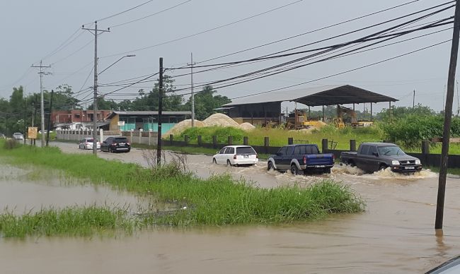
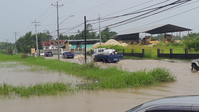
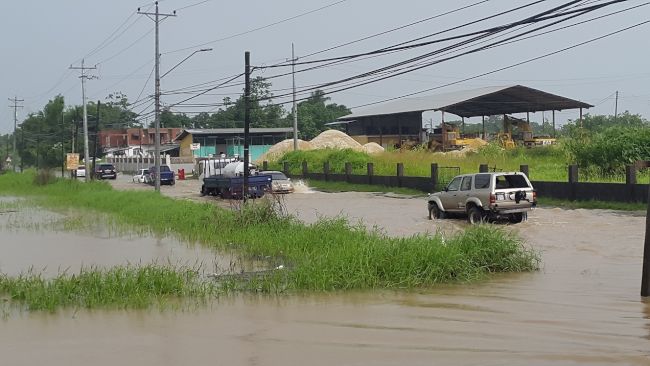
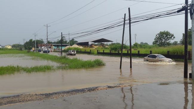
Localized street or flash flooding is likely in
heavy or prolonged downpours and gusty winds may
be experienced in the vicinity of showers or
thundershowers. There is also the likelihood of
landslides/landslips in elevated areas.

Citizens are advised to be vigilant and cautious
as they conduct their activities and to pay
attention to the media or visit our website at
http://www.metoffice.gov.tt/forecast for daily weather
updates at 6am, 10am, 3pm and 6pm.

We wish to underscore that at this time Trinidad
and Tobago is not under any Tropical Storm threat,
Watch or Warning. The Trinidad and Tobago
Meteorological Service will continue to closely
monitor this weather event and will issue another
bulletin if the situation warrants.

Shakeer Baig
Meteorologist

User avatar
rollingstock
TriniTuner 24-7
Posts: 17912
Joined: June 29th, 2009, 8:21 am
Location: Ain't got no chill!

Re: The official tropical weather thread 2016

Postby rollingstock » July 14th, 2016, 11:48 am

Central.
Attachments
IMG-20160714-WA0000.jpg

User avatar
killercow
Riding on 17's
Posts: 1485
Joined: July 29th, 2010, 6:33 pm
Location: The Mega Trance Thread!

Re: The official tropical weather thread 2016

Postby killercow » July 14th, 2016, 11:54 am

rollingstock wrote:Central.

Which part ah central is this RS?

User avatar
rollingstock
TriniTuner 24-7
Posts: 17912
Joined: June 29th, 2009, 8:21 am
Location: Ain't got no chill!

Re: The official tropical weather thread 2016

Postby rollingstock » July 14th, 2016, 11:57 am

Welcome road cunupia.

pugboy
TunerGod
Posts: 25534
Joined: September 6th, 2003, 6:18 pm

Re: The official tropical weather thread 2016

Postby pugboy » July 14th, 2016, 12:15 pm

so we might actually see fitzgerald hinds come outside for a change

User avatar
JF.K
Chronic TriniTuner
Posts: 544
Joined: April 14th, 2014, 6:57 pm
Location: Completing Another Honest Transaction

Re: RE: Re: The official tropical weather thread 2016

Postby JF.K » July 14th, 2016, 4:05 pm

rollingstock wrote:Central.

Like that AD Wagon is a rental...
You drive through that?

User avatar
rollingstock
TriniTuner 24-7
Posts: 17912
Joined: June 29th, 2009, 8:21 am
Location: Ain't got no chill!

Re: The official tropical weather thread 2016

Postby rollingstock » July 14th, 2016, 4:14 pm

Lol not my pic, brother, and yes he did. I've seen him do worst.

User avatar
Duane 3NE 2NR
Admin
Posts: 27225
Joined: March 24th, 2003, 10:27 am
Location: T&T
Contact:

Re: The official tropical weather thread 2016

Postby Duane 3NE 2NR » July 14th, 2016, 10:31 pm

Bulletin #2

Date: Thursday 14th of July 2016
ISSUED AT: 06:10 PM

The Trinidad and Tobago Meteorological Service is
issuing a riverine flood alert for Trinidad,
having regard to this most recent rainfall
activity associated with the Inter-Tropical
Convergence Zone (ITCZ) over the last 18 hours. As
oppose to Street and Flash Flooding, Riverine
Flooding is more prolong and widespread.

Reports from the Water Resources Agency indicate
that water levels in the nation’s major rivers
are approaching threshold levels as a result of
expected run-off from the current rainfall event.
Although water levels in the primary Caroni River
remain contained at this time, it is nevertheless
threateningly high.

Meteorological Forecasts and data obtained from
Numerical Weather Prediction Models indicate that
further rainfall activity is expected over the
next 12 to 18 hours with rainfall accumulation
anticipated to be between 20-40 millimeters.
Given the additional rainfall predicted for
Trinidad and Tobago and the occurrence of high
tides at 12:04 am. (15/07/16), the possibility of
river overtopping is real and imminent.

Citizens in general, and those residing in the
Caroni River Basin in particular, are asked to be
on the alert for rising river levels and possible
overspill. All necessary measures MUST be taken to
preserve life and property

WE STRONGLY UNDERSCORE THAT TRINIDAD AND TOBAGO IS
NOT UNDER ANY TROPICAL STORM THREAT, WATCH OR
WARNING AT THIS TIME. The Trinidad and Tobago
Meteorological Service is closely monitoring
weather conditions and will issue another bulletin
at 6:00 am tomorrow or sooner if warranted.

Akil Nancoo
Meteorologist

ron_28
Sweet on this forum
Posts: 297
Joined: June 12th, 2009, 10:31 am

Re: The official tropical weather thread 2016

Postby ron_28 » July 15th, 2016, 10:30 am

by the old airport in piarco via cnc3
Attachments
13697287_1066131720138663_1374199479504984604_n.jpg
13697287_1066131720138663_1374199479504984604_n.jpg (10.14 KiB) Viewed 7342 times

User avatar
Duane 3NE 2NR
Admin
Posts: 27225
Joined: March 24th, 2003, 10:27 am
Location: T&T
Contact:

Re: The official tropical weather thread 2016

Postby Duane 3NE 2NR » July 15th, 2016, 11:46 am

Bulletin ##3

Date: Friday 15th of July 2016
ISSUED AT: 06:17 AM

RIVERINE FLOOD ALERT!


The Trinidad and Tobago Meteorological Service is
issuing a riverine flood alert for Trinidad,
having regard to this most recent rainfall
activity associated with the Inter-Tropical
Convergence Zone (ITCZ) over the last 18 hours. As
oppose to Street and Flash Flooding, Riverine
Flooding is more prolong and widespread.


Reports from the Water Resources Agency indicate
that water levels in the nation’s major rivers
are approaching threshold levels as a result of
expected run-off from the current rainfall event.
Although water levels in the primary Caroni River
remain contained at this time, it is nevertheless
threateningly high.


Meteorological Forecasts and data obtained from
Numerical Weather Prediction Models indicate that
further rainfall activity is expected over the
next 12 to 18 hours with rainfall accumulation
anticipated to be between 20-40
millimeters. Given the additional rainfall
predicted for Trinidad and Tobago and the
occurrence of high tides at 12:36 p.m. today, the
possibility of river overtopping is real and
imminent.


Citizens in general, and those residing in the
Caroni River Basin in particular, are asked to be
on the alert for rising river levels and possible
overspill. All necessary measures MUST be taken to
preserve life and property. WE STRONGLY
UNDERSCORE THAT TRINIDAD AND TOBAGO IS NOT UNDER
ANY TROPICAL STORM THREAT, WATCH OR WARNING AT
THIS TIME. The Trinidad and Tobago Meteorological
Service is closely monitoring weather conditions

User avatar
Duane 3NE 2NR
Admin
Posts: 27225
Joined: March 24th, 2003, 10:27 am
Location: T&T
Contact:

Re: The official tropical weather thread 2016

Postby Duane 3NE 2NR » July 15th, 2016, 11:47 am

And more rain coming

avn-l-1.jpg


USA.gif

User avatar
JF.K
Chronic TriniTuner
Posts: 544
Joined: April 14th, 2014, 6:57 pm
Location: Completing Another Honest Transaction

Re: The official tropical weather thread 2016

Postby JF.K » July 15th, 2016, 3:35 pm

Madras and Environs under water... This is Madras Road (St. Helena) here:

Image

Image

Image

Image

This flood backing up all the way to the airport.

St Helena and Las Lomas all flooded.
Heavy Traffic entering these areas.

toyolink
3NE 2NR Power Seller
Posts: 2781
Joined: May 22nd, 2010, 11:24 am

Re: The official tropical weather thread 2016

Postby toyolink » July 15th, 2016, 4:04 pm

This is going to be bad!
Clearly, the environment just not in a position to handle this deluge.
High tide condition will certainly cause delayed back-up of flows and this may go into tomorrow.

User avatar
JF.K
Chronic TriniTuner
Posts: 544
Joined: April 14th, 2014, 6:57 pm
Location: Completing Another Honest Transaction

Re: The official tropical weather thread 2016

Postby JF.K » July 15th, 2016, 6:12 pm

If this is not reaching full capacity, I don't know what is...
The Caroni River at present:

Image

Image

Image

User avatar
JF.K
Chronic TriniTuner
Posts: 544
Joined: April 14th, 2014, 6:57 pm
Location: Completing Another Honest Transaction

Re: The official tropical weather thread 2016

Postby JF.K » July 15th, 2016, 7:21 pm

nick639 wrote:^^ remember the night we qualified for germany 2006??? Caroni bank had buss yes, north bound highway had to be dual carriageway

Lets hope it doh reach that bad

Guess What... It is that bad...

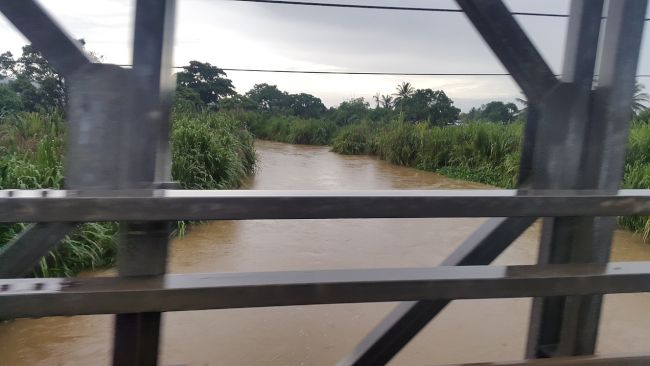
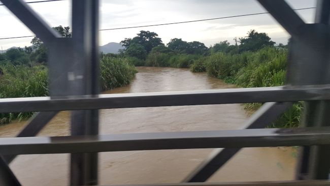
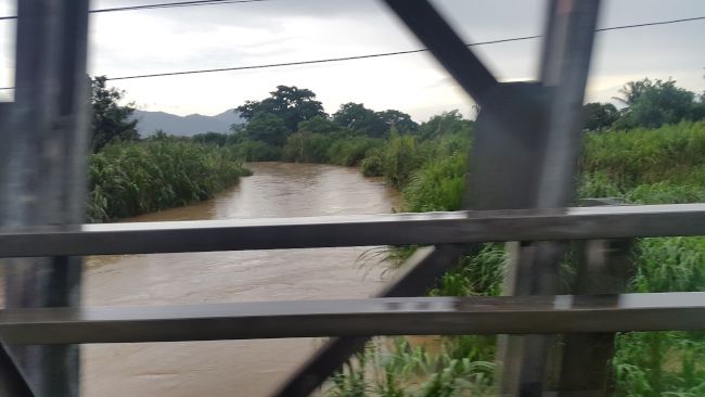
ODPM: Caroni river overflows its banks

BY: Alina Doodnath
5:28pm, July 15, 2016

The Office of Disaster Preparedness and Management has issued another Riverine Flood Alert informing that several rivers, including the Caroni River, have burst their banks.


According to a release issued at 4:30 pm Friday, the Trinidad and Tobago Meteorological Service said it is maintaining its alert due to extended heavy rainfall and citizens are likely to experience “more prolonged and widespread flooding” as opposed to street and flash flooding, through the occurrence of riverine flooding.

Current rainfall activity is a result of a passing Inter-Tropical Convergence Zone, stimulated by an active Tropical Wave.


“Reports from the Water Resources Agency indicate that water levels in the larger rivers, in particular the Caroni River have over-spilled their banks.”

“As a result, smaller river courses particularly in North Eastern and Central Trinidad have been affected and have also over-spilled their banks.”

“In addition, further run-off from the current rainfall event is expected which will exacerbate the current flooding situation.”

Affected areas include:

Central Trinidad

Brazil Village

Caparo

Cunupia

El Carmen

Endeavour

Enterprise

Kelly Village

La Horquetta

Las Lomas

Mamoral

Oropune Gardens

Oropune Village

Piarco

San Raphael

Talparo

Tumpuna

Welcome Chin Chin


East Trinidad

Cunaripo

Manzanilla

Sangre Chiquito

Sangre Grande

Arima.

Landslides have also been reported in the Arima area.

The following roads are reported to have been affected by flooding:
•Caroni South Bank Road
•Golden Grove Road (intersection)
•Jerningham Road
•Munroe Road
•Todd’s Station Road
•Tumpuna Road
•Caparo Road

“Persons commuting to and from these areas should delay travel or find alternative routes if possible, while proceeding with extreme caution.”

“The Trinidad and Tobago Meteorological Service has advised that given the additional rainfall predicted for Trinidad and Tobago and the occurrence of the high tide at approximately 12:52 a.m.”

The Met Office says this flooding situation is expected to continue for at least the next 24 to 36 hours.

Citizens have reported that the Las Lomas river has burst its banks while El Carmen is presently underwater and the Madrass road has also flooded.

The ODPM also advised citizens to stay inside after heavy rainfall until water levels have subsided and it is safe to venture outside: "Do not walk/drive through flood waters. Be cautious when walking/driving along hillsides or landslide-prone areas."

The Met Office reiterates that Trinidad and Tobago is NOT currently under any Tropical Storm threat, Watch or Warning.

The TT Meteorological Service is monitoring this weather condition and will advise the ODPM as necessary.

The ODPM reminds all citizens that if they have been affected by this inclement weather, to please contact their Customer Care Centre at 511 and check the website http://www.odpm.gov.tt for additional safety tips and take all measures to preserve life and property.

Citizens may also access the Emergency Hotlines for first responder services and their respective Disaster Management Units on the ODPM’s mobile application “Disaster Ready”.

The Priority Bus Route has also been opened until 12:00 am Saturday to facilitate commuters.

http://www.looptt.com/content/odpm-caro ... -its-banks


pugboy
TunerGod
Posts: 25534
Joined: September 6th, 2003, 6:18 pm

Re: The official tropical weather thread 2016

Postby pugboy » July 15th, 2016, 7:26 pm

Tide supposed to be low around now, better hope water gets out fast and no more rain before next high tide

User avatar
JF.K
Chronic TriniTuner
Posts: 544
Joined: April 14th, 2014, 6:57 pm
Location: Completing Another Honest Transaction

Re: The official tropical weather thread 2016

Postby JF.K » July 15th, 2016, 7:37 pm

pugboy wrote:Tide supposed to be low around now, better hope water gets out fast and no more rain before next high tide


LoopTT wrote:The Met Office says this flooding situation is expected to continue for at least the next 24 to 36 hours


User avatar
Pablo660
Chronic TriniTuner
Posts: 679
Joined: December 10th, 2003, 9:49 am
Location: Gasp

The official tropical weather thread 2016

Postby Pablo660 » July 15th, 2016, 8:02 pm

Good time to own a 4x4 yes
Available for rescues if needed
Ru$$ell or myself, we going tru almost anything

User avatar
JF.K
Chronic TriniTuner
Posts: 544
Joined: April 14th, 2014, 6:57 pm
Location: Completing Another Honest Transaction

Re: The official tropical weather thread 2016

Postby JF.K » July 15th, 2016, 10:45 pm

Pablo660 wrote:Good time to own a 4x4 yes
Available for rescues if needed
Ru$$ell or myself, we going tru almost anything

Dem 4x4 better come with a Yamaha Outboard cause wheels can't help in some places

User avatar
JF.K
Chronic TriniTuner
Posts: 544
Joined: April 14th, 2014, 6:57 pm
Location: Completing Another Honest Transaction

Re: The official tropical weather thread 2016

Postby JF.K » July 15th, 2016, 10:49 pm

Guys... I just drive over that Caroni Bridge.
Scary as Hell!
The reflection of the water was just under the bridge.
Looks as though it was touching the bridge as the high water current passed by.
Real Horror picture thing

Advertisement

Return to “Ole talk and more Ole talk”

Who is online

Users browsing this forum: No registered users and 233 guests