Flow
Flow
TriniTuner.com  |  Latest Event:  

Forums

2010 and 2011 Tropical weather discussion

this is how we do it.......

Moderator: 3ne2nr Mods

User avatar
Greypatch
3NE 2NR Moderator
Posts: 27560
Joined: April 22nd, 2003, 11:00 am
Location: On the Road....
Contact:

Re: The official tropical weather thread: image updates on p

Postby Greypatch » September 17th, 2010, 2:08 pm

south peeps if it have flood in the M2 let us know.

User avatar
nareshseep
punchin NOS
Posts: 3333
Joined: June 29th, 2007, 12:41 pm
Location: down town

Re: The official tropical weather thread: image updates on p

Postby nareshseep » September 17th, 2010, 2:16 pm

Anyone see some dread lightning last night, also first time I heard thunder constantly rumbling without no stopping, it sounded like if someone was dragging furniture for about an hour non stop

User avatar
silent_riot
punchin NOS
Posts: 4495
Joined: December 26th, 2004, 11:40 pm
Location: Pumpitating
Contact:

Re: The official tropical weather thread: image updates on p

Postby silent_riot » September 17th, 2010, 3:06 pm

Igor looking like he going and clout we a dred backhand.

M_2NR
not Admin
Posts: 7247
Joined: December 18th, 2008, 9:46 pm

Re: elsocorro area now bucket ah drop.

Postby M_2NR » September 17th, 2010, 3:25 pm

VexXx Dogg wrote:UWI black like night, expecting the downpour any moment.

ent! was in sac, thankfully it didnt last too long.

Time to buss a sleep yo

User avatar
hustla_ambition101
TriniTuner 24-7
Posts: 8093
Joined: February 1st, 2007, 1:55 pm
Location: waiting....

Re: The official tropical weather thread: image updates on p

Postby hustla_ambition101 » September 17th, 2010, 5:45 pm

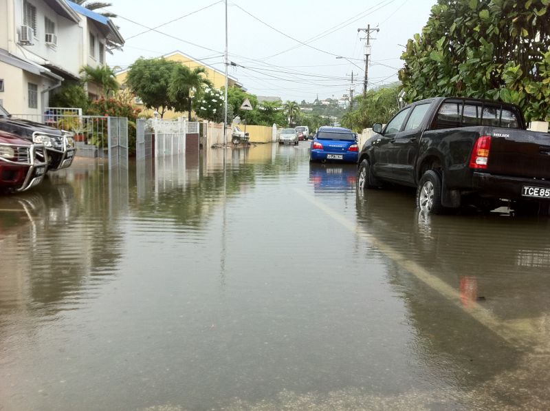
nismotrinidappa wrote:current went in macoya.... flooding.. people stranded

oh gawd boidanwatwegodoboidan


and the two jackarse policemen stand up under the bus shed instead of directing the traffic

User avatar
kaviman
3NE 2NR for life
Posts: 107
Joined: May 12th, 2009, 10:02 am
Location: South
Contact:

Re: The official tropical weather thread: image updates on p

Postby kaviman » September 17th, 2010, 6:11 pm

Greypatch wrote:south peeps if it have flood in the M2 let us know.


no flood in south as of half hour ago.... just passed pn the m2

redmanjp
TriniTuner 24-7
Posts: 17608
Joined: September 22nd, 2009, 11:01 pm
Contact:

Re: The official tropical weather thread: image updates on p

Postby redmanjp » September 17th, 2010, 6:12 pm

real rain early afternoon in Aranguez- sky was real dark like it was after 6PM

we had to put sandbags close to a small drain which runs close to our office doorway

User avatar
rollingstock
TriniTuner 24-7
Posts: 17931
Joined: June 29th, 2009, 8:21 am
Location: Ain't got no chill!

Re: The official tropical weather thread: image updates on p

Postby rollingstock » September 17th, 2010, 9:21 pm

pioneer wrote:rain doh bother me, look gyul doh vex wid me
we sleepin whole day an in de night


Ewwwww, indo trinis :|

User avatar
hot blue
3NE2NR is my LIFE
Posts: 781
Joined: April 21st, 2003, 2:55 pm
Location: Pt Radix 2000' talk 2u inbound
Contact:

Re: The official tropical weather thread: image updates on p

Postby hot blue » September 17th, 2010, 10:18 pm

check this site out
lasted about 10mins max
real strange stuff


Image

User avatar
Duane 3NE 2NR
Admin
Posts: 28648
Joined: March 24th, 2003, 10:27 am
Location: T&T
Contact:

Re: The official tropical weather thread: image updates on p

Postby Duane 3NE 2NR » September 17th, 2010, 11:12 pm

^ What the hell was that?

could have been a or shelf cloud
Image

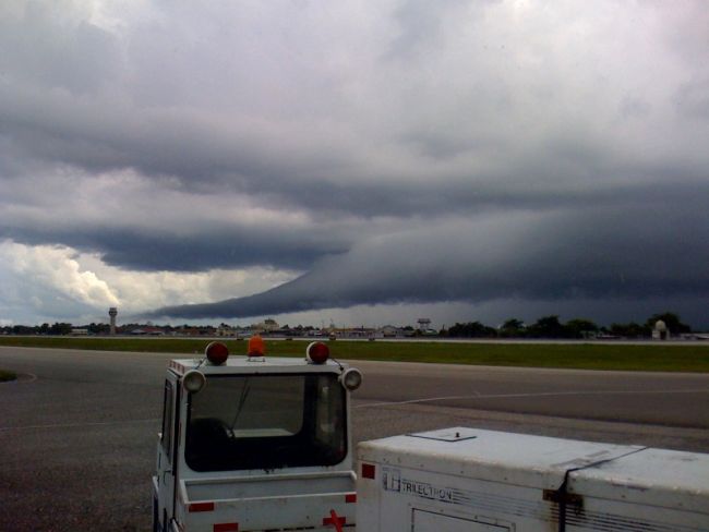
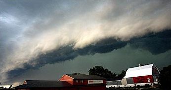
A derecho (from Spanish: "derecho" meaning "straight")[8] is a widespread and long-lived, violent convectively induced straight-line windstorm that is associated with a fast-moving band of severe thunderstorms usually taking the form of a bow echo. Derechos blow in the direction of movement of their associated storms, similar to a gust front, except that the wind is sustained and generally increases in strength behind the "gust" front. A warm weather phenomenon, derechos occur mostly in summer, between May and August in the Northern hemisphere. They can occur at any time of the year and occur as frequently at night as in the daylight hours.[9]

The traditional criteria that distinguish a derecho from a severe thunderstorm are sustained winds of 58 miles per hour (93 km/h) during the storm as opposed to gusts, high and/or rapidly increasing forward speed, and geographic extent (typically 250 nautical miles (460 km) in length.)[6] In addition, they have a distinctive appearance on radar (bow echo); several unique features, such as the rear inflow notch and bookend vortex, and usually manifest two or more downbursts. Although these storms most commonly occur in North America, derechos occur elsewhere in the world. Outside North America they may be called by different names. For example, in Bangladesh and adjacent portions of India, a type of storm known as a "Nor'wester" may be a progressive derecho.[9

User avatar
Hook
3NE 2NR Moderator
Posts: 13225
Joined: January 18th, 2004, 9:55 am
Location: The 6%.

Re: The official tropical weather thread: image updates on p

Postby Hook » September 17th, 2010, 11:13 pm

^^^ See that white dome on the extreme right? That cloud looked totally different from by that white dome.

User avatar
xtech
punchin NOS
Posts: 3003
Joined: March 15th, 2006, 2:01 pm
Contact:

Re: The official tropical weather thread: image updates on p

Postby xtech » September 17th, 2010, 11:28 pm

originalbling wrote:Hook, Julia is moving faster than Igor.

Can both low pressure areas merge? what will be the effects of such?


The rare effect of two interacting hurricanes is termed the Fujiwhara effect.

In the Fujiwhara Effect, two tropical cyclones can alter each other and/or become absorbed by the stronger of the two hurricanes also storm paths can be altered by their interactions with each other. Those two storms can collide and become larger, but not more powerful. One storm is usually absorbed.

The storm may later become more powerful, but that does not mean it was from the collision.

Image

Igor is murdering sweet defenseless Julia

User avatar
Hook
3NE 2NR Moderator
Posts: 13225
Joined: January 18th, 2004, 9:55 am
Location: The 6%.

Re: The official tropical weather thread: image updates on p

Postby Hook » September 17th, 2010, 11:36 pm

but "derecho" means "right" (as in the opposite of "left") :?

User avatar
brickman
18 pounds of Boost
Posts: 2343
Joined: February 2nd, 2010, 10:08 am
Location: In a happy place

Re: The official tropical weather thread: image updates on p

Postby brickman » September 19th, 2010, 1:50 pm

Tornado just pass through belmont,1 house confirmed roofless,others damaged,lamposts down.My knees still knocking,real scary!!
Attachments
Photo-0010.jpg
Photo-0010.jpg (51.73 KiB) Viewed 2073 times

User avatar
xtech
punchin NOS
Posts: 3003
Joined: March 15th, 2006, 2:01 pm
Contact:

Re: The official tropical weather thread: image updates on p

Postby xtech » September 19th, 2010, 4:18 pm

only one picture............walk around nah man get out the house take more pictures

User avatar
dog4life
Street 2NR
Posts: 32
Joined: January 30th, 2010, 5:37 pm

Re: The official tropical weather thread: image updates on p

Postby dog4life » September 19th, 2010, 4:26 pm

jus saw this on facebook on CNC3 site:CNC3 Television IMPORTANT: The Trinidad and Tobago Meteorological Service has issued an Information Bulletin
advising that over the next three hours, there is the strong
possibility that both islands (particularly western Trinidad) will
experience heavy and intense showers and isolated thundershowers. BE VIGILANT!

User avatar
mitsu_chick941
3ne2nr Toppa Toppa
Posts: 5060
Joined: April 17th, 2008, 7:20 am
Location: in yuh inbox

Re: The official tropical weather thread: image updates on p

Postby mitsu_chick941 » September 19th, 2010, 7:42 pm

no rain on my side but i keep hearing thunder and seeing lightening :? :? :?

User avatar
xtech
punchin NOS
Posts: 3003
Joined: March 15th, 2006, 2:01 pm
Contact:

Re: The official tropical weather thread: image updates on p

Postby xtech » September 19th, 2010, 8:24 pm

Poor Bermuda. Igor wiping them off the map as we speak

User avatar
X_Factor
TriniTuner 24-7
Posts: 9581
Joined: April 27th, 2003, 5:54 pm
Location: St. Augustine
Contact:

Re: The official tropical weather thread: image updates on p

Postby X_Factor » September 19th, 2010, 9:03 pm

trinidad is really in a blessed location yes

but imagine of one of those continue straight instead of pushing upwards

User avatar
brickman
18 pounds of Boost
Posts: 2343
Joined: February 2nd, 2010, 10:08 am
Location: In a happy place

Re: The official tropical weather thread: image updates on p

Postby brickman » September 20th, 2010, 10:55 am

Looks like some serious weather to the east moving in after noon.Might be pressure later!Not playing after yesterdays drama.

User avatar
apple
Trinituner Peong
Posts: 425
Joined: November 18th, 2008, 7:16 pm
Location: San Fernando

Re: The official tropical weather thread: image updates on p

Postby apple » September 20th, 2010, 1:06 pm

heavy rain in sando

User avatar
SUPAstarr
punchin NOS
Posts: 3074
Joined: January 31st, 2005, 12:46 pm
Location: STAMINA STAMINA STAMINA STAMINA
Contact:

Re: The official tropical weather thread: image updates on p

Postby SUPAstarr » September 21st, 2010, 9:14 am

OMG A TROPICAL WAVE IS NEAR WOOOOGAAAAAAD, HOOK shud i run for cover from now.. P A N I C

User avatar
AYE_SOLDIER
Shifting into 6th
Posts: 2027
Joined: April 5th, 2007, 2:41 pm
Location: "you cant fake fresh!"

Re: The official tropical weather thread: image updates on p

Postby AYE_SOLDIER » September 21st, 2010, 9:37 am

damn its gonna rain again :(

User avatar
MG Man
2NRholic
Posts: 23902
Joined: May 1st, 2003, 1:31 pm
Location: between cinco leg

Re: The official tropical weather thread: image updates on p

Postby MG Man » September 21st, 2010, 10:04 am

apple wrote:heavy rain in sando


you put ah scale out in de rain or summ?
how you know it heavy?

User avatar
snowman
Chronic TriniTuner
Posts: 546
Joined: April 23rd, 2007, 11:28 am
Contact:

Re: The official tropical weather thread: image updates on p

Postby snowman » September 21st, 2010, 10:10 am

:shocked!:
SUPAstarr wrote:OMG A TROPICAL WAVE IS NEAR WOOOOGAAAAAAD, HOOK shud i run for cover from now.. P A N I C


What he said.

SRASC
3NE 2NR Moderator
Posts: 3272
Joined: January 13th, 2008, 10:53 am

Re: The official tropical weather thread: image updates on p

Postby SRASC » September 21st, 2010, 10:24 am

I know I'm late but

Image
September 19 2010 - 2:18PM

User avatar
noshownogo
punchin NOS
Posts: 4379
Joined: January 6th, 2004, 11:51 am
Location: heavy petting!
Contact:

Re: The official tropical weather thread: image updates on p

Postby noshownogo » September 21st, 2010, 10:34 am

^^since when there floods like that? Tide was high as well?

User avatar
Duane 3NE 2NR
Admin
Posts: 28648
Joined: March 24th, 2003, 10:27 am
Location: T&T
Contact:

Re: The official tropical weather thread: image updates on p

Postby Duane 3NE 2NR » September 21st, 2010, 11:24 am

flood doh discriminate.

User avatar
apple
Trinituner Peong
Posts: 425
Joined: November 18th, 2008, 7:16 pm
Location: San Fernando

Re: The official tropical weather thread: image updates on p

Postby apple » September 21st, 2010, 4:52 pm

MG Man wrote:
apple wrote:heavy rain in sando


you put ah scale out in de rain or summ?
how you know it heavy?


duh!! :roll:

User avatar
teems1
punchin NOS
Posts: 3448
Joined: March 15th, 2007, 4:44 pm

Re: The official tropical weather thread: image updates on p

Postby teems1 » September 21st, 2010, 4:58 pm

real lightning and thunder and rain here in endeavour

Advertisement

Return to “Ole talk and more Ole talk”

Who is online

Users browsing this forum: No registered users and 39 guests